Paper giant APP linked to Indonesia peat clearing despite sustainability vow


- Greenpeace Southeast Asia has identified nearly 3,500 hectares (8,650 acres) of peatland clearing in pulpwood plantations in Sumatra supplying Asian Pulp & Paper.
- Analysis of satellite imagery showed the clearing began in August 2018 and continued through June this year, despite APP having a “no peatland” and “no burning” policy that it also imposes on its suppliers.
- Greenpeace and local NGO Jikalahari also found evidence of fires in the concessions in question, which appeared to have been set deliberately to clear the land for planting.
- APP has denied clearing the peatland or setting the fires, calling into question the accuracy of the maps used and saying the fires spread from neighboring farms.
JAKARTA — Suppliers to Indonesia’s biggest producer of pulpwood for paper cleared an area of carbon-rich peatland 10 times the size of New York City’s Central Park, in possible violation of its sustainability commitments, a new analysis by Greenpeace shows.
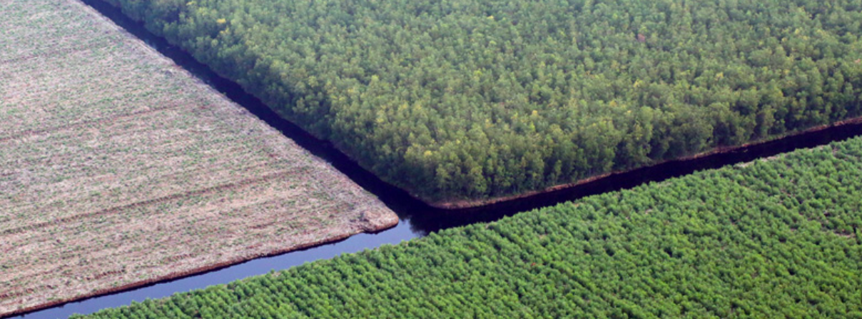
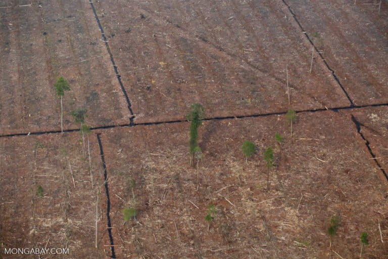
The conservation NGO used freely available satellite imagery and detailed spatial information to determine that nearly 3,500 hectares (8,650 acres) of peatland, an area the size of 6,500 football fields, was cleared in three concessions with ties to Asia Pulp & Paper (APP) between August 2018 and June 2020. Peat clearing is typically done ahead of planting pulpwood trees such as acacia and eucalyptus.
The concessions, on the island of Sumatra, are held by the companies PT Arara Abadi (AA), PT Bumi Andalas Permai (BAP) and PT Bumi Mekar Hijau (BMH), which are either owned by APP or are major suppliers to the company.
The largest peat clearing was found in the BMH concession and spanned 2,110 hectares (5,213 acres) from August 2018, followed by BAP with 1,200 hectares (2,965 acres) in the same period, and AA with 170 hectares (420 acres) from January 2020.
The analysis by Greenpeace Southeast Asia also found 53 kilometers (32 miles) of drainage canals dug in the same period, a practice that dries out the moist peat layer and renders it highly susceptible to catching fire. Sumatra is routinely blanketed with toxic haze from peat fires, which represent both a public health threat and a major source of greenhouse gas emissions.
All three concession holders have a history of fires. BMH, for instance, was found guilty by a court over fires on 20,000 hectares (49,400 acres) of its concessions in 2014; the following year, another 63,000 hectares (155,700 acres) of its concession burned again.
During last year’s burning season, there were more fire alerts inside the BMH concession than that of any other pulpwood producer, according Greenpeace’s analysis of NASA data.
More recently, fires were detected inside AA’s concession in Riau province, burning 83 hectares (205 acres) of land since June 28. Jikalahari, an environmental NGO that deployed a team to the site to verify the fires, said the burned location had already been staked out, indicating it was being prepared to be planted with acacia trees. The team also found recently planted acacias that weren’t burned in some locations.
“AA deliberately set fires [on its concession] to be planted with acacia,” said Jikalahari deputy coordinator Okto Yugo Setyo. He said the company wanted to clear the land cheaply, for which burning, though illegal, remains the method of choice across Indonesia.
Kiki Taufik, head of the Indonesia forest campaign at Greenpeace Southeast Asia, said the peat clearance and the digging of drainage canals were blatant violations of APP’s sustainability commitments.
Following widespread criticism of its role in driving deforestation and contributing to social conflicts, APP launched in 2013 its Forest Conservation Policy (FCP), in which it pledged to not destroy natural forests for its pulpwood plantations. The following year, APP publicly announced its commitment to restore a million hectares (2.47 million acres) of ecosystems in Indonesia, representing an area equivalent to the total plantation area from which it sourced its pulpwood in 2013.
But green groups have criticized APP for the sluggish progress of its FCP, attributing some of the problems to lack of transparency. And with the recent findings from the Greenpeace analysis, Kiki said APP has “backtrack[ed] on their commitments to protect and restore the ecosystems they have destroyed.”
“This makes a mockery of their attempts to talk about sustainability approaches with their stakeholders,” he said. “No company that claims to care about the environment can continue to trade with APP.”

Blaming the neighbors
APP has denied the allegations of peatland clearing by the three associated concession holders, saying it has had a strict policy in place since 2013 of not converting peatland and not burning. It said it has also implemented several programs to address fires in its concessions.
“[But] while APP suppliers are prohibited from land clearance by fire, this does not mean that no fires will ever take place within concessions,” the company said. “There are, however, still challenges on the ground due to the complexity of the land use within our suppliers’ concessions. This can include villages located inside and around the concessions.”
AA also denied the allegations of recent fires burning inside its concession. The team sent by Jikalahari to investigate the fires also received reports that the fires spread from outside AA’s concession.
But according to the team’s findings, the farms where the fires were said to have originated were more than half a kilometer from AA’s concession, and there was no burned land in between, making it improbable that the fires came from outside.
“In fact, it was AA’s concession that was deliberately burned because the fires only razed areas that had already been staked and they didn’t reach areas that have been planted [with acacias], even though they’re only separated by a canal,” Jikalahari’s Okto said.
And by using images from the Sentinel-2 Earth observation satellite, Jikalahari was able to trace the history of the burned areas in AA’s concession. In January 2020, the burned areas were natural forests covered with shrubs. In February, land clearing started. In May, the drainage canals were dug, and in June, the land clearing continued, resulting in the fires that started on June 28, according to Jikalahari’s analysis.
APP said that despite all its efforts to ensure no fires on its concessions, some would inevitably break out.
“There is no foolproof system,” the company said. “We have encountered lapses in the past and will likely make mistakes in the future, but our willingness to close loopholes and stick to our commitments is clear.”

Data and maps
APP questioned the maps used by Greenpeace in its analysis, saying they’re not clear. It said that Deltares, a Dutch consultancy with expertise in wetlands issues, had mapped all of the company’s suppliers’ concessions, including both plantation and conservation areas, using a high-resolution laser surveying technique known as lidar.
The company said the latest mapping was done in 2018, which produced a highly accurate peat map that’s been shared with the Ministry of Environment and Forestry for use in its peat ecosystem function map.
Kiki said APP had failed to back up its denials with evidence, given that its maps have never been published.
“Greenpeace has provided clear evidence that shows APP cutting new canals through peatland and conversion of natural vegetation, contrary to its commitments,” he said. “APP has provided no evidence to refute this.”
Kiki added that if APP was so sure there was no peatland cleared or drainage canals dug on its associated concessions, then it should have no problem releasing the maps to the public.
“Where are its ‘highly accurate’ peatland maps from 2018 that APP claims to have? Where are the satellite images proving it has not dug any more drainage canals?” he said.
Greenpeace said it used the environment ministry’s own peat ecosystem function map — which APP said it had contributed to — for its analysis, and found that the clearing took place within protected peat areas in each of the concessions. It also used the ministry’s land cover map to find that the dominant vegetation type cleared was swamp shrub, the primary forest vegetation for this kind of landscape.
“The satellite images of fires burning in APP’s concession at the end of June 2020 are undeniable,” Kiki said. “Yet APP claims that it has a Zero Burning policy and does not engage in burning of land for clearing, instead blaming neighboring farmers for the fires.”
Too boost transparency, APP has made its forest alert data available for public access since May 2020 on its forest monitoring dashboard.
“The Dashboard aims to assist interested parties to better track and understand the zero deforestation commitment including forest cover monitoring on protected conservation area within its supply chain,” APP said. “These initiatives are just some examples of APP’s endeavor to be open and accountable.”
Some NGOs have questioned why the dashboard only monitors protected areas, and not the rest of the company and its suppliers’ concessions, which cover 2.6 million hectares (6.42 million acres) of land.
APP said the service is focused on protecting conservation forests, which are determined by high carbon value (HCV) and high carbon stock (HCS) assessments. APP said these areas are forested, while the rest of its suppliers’ concessions consist of plantation areas and land set aside for community livelihood, which are not forested.
Kiki said that if the dashboard was focused on monitoring protected forest areas, it should have been able to detect the peatland clearing and drainage canal digging reported by Greenpeace. He said there seemed to be a disconnect between APP’s dashboard and the reality on the ground.
“If they’ve been able to define which areas can’t be cleared because they’re of high conservation value and of high carbon stock and mapped these areas, there should be signs on the field [that identify such areas],” Kiki said.
“Does the alert monitoring feature of the dashboard run well? Is it true that they really monitor [their concessions] routinely and in detail?” Kiki added. “If they say that they monitor, then why is there peat clearing?”
Banner image: Photo of an acacia plantation in various stages of harvest in Indonesia. Image by Rhett A. Butler/Mongabay.
Source
Language of the news reported
Copyright © Source (mentioned above). All rights reserved. The Land Portal distributes materials without the copyright owner’s permission based on the “fair use” doctrine of copyright, meaning that we post news articles for non-commercial, informative purposes. If you are the owner of the article or report and would like it to be removed, please contact us at hello@landportal.info and we will remove the posting immediately.
Various news items related to land governance are posted on the Land Portal every day by the Land Portal users, from various sources, such as news organizations and other institutions and individuals, representing a diversity of positions on every topic. The copyright lies with the source of the article; the Land Portal Foundation does not have the legal right to edit or correct the article, nor does the Foundation endorse its content. To make corrections or ask for permission to republish or other authorized use of this material, please contact the copyright holder.
